Know before you go!
Hazards along fire affected area roads-
As a result of the Okanogan Complex fires, the Okanogan Wenatchee National Forest has issued an area closure order, effective Friday, September 4, 2015. The public is not allowed on federal lands, roads, and trails within the area closure. Closure order information is available on Inciweb HERE
Also, be advised there are many hazards along the fire affected open roads. Please use extreme caution when driving through fire areas. Stay alert and be aware of fire equipment and firefighters working along the roads. Drive with headlights on and do not stop or park along the roads to watch the fire or firefighting activities. Also be aware that hazard trees and rocks could fall on the roads. Use EXTREME caution in and around these areas.
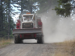
Skidgines being used to assist mop up operations on the Lime Belt fire on September 5.
A little more about Skidgines-
Skidgines have a water-holding capacity of eight hundred to twenty-five hundred gallons. They can traverse terrain that an engine cannot, providing a close source of water to firefighters and reducing the amount of hose needed as they mop-up far from roads. They are suited well to patrol firelines and cover great distances to find water.
Test Burn Conducted off NFSR 42
The Redmond Hotshots conduct a 2-acre test burn to determine
if conditions are right for firing operations on the west side of
the Lime Belt Fire on the Okanogan Complex (August 5, 2015).
Heather Reichert (Bend, Oregon)-Redmond Hotshots
Redmond Hotshots hike to the test burn.
Hiking to the test burn site.
Lighting the test burn with a drip torch.
High RHs from cloud cover and moist conditions caused fine fuels and
grass not to burn. Larger fuels which take a long time to dry and a long time
to wet again burned while fine fuels did not. Only partial removal of the unburned fuels
made for an unsuccessful test burn, so the larger firing operation was postponed.
Michael Rooffener - Modock National Forest- home unit (right) and
Lonnie Kuehne - Colville Agency - home unit (left)
Retardant Drop
Atmospheric Sounding
Recently the IMET (Incident Meteorologist) Todd Carter released an atmospheric sounding weather balloon at the Okanogan Complex Incident Command Post. Measurement of the condition of the atmosphere over the fire area assists the IMET in developing an incident specific weather forecast.
The balloon is filled with helium until it is close to neutral buoyancy.
The sounding instrument package is attached to the balloon.
Balloon height and incoming data is tracked as the balloon rises through the atmosphere.
Incident Meteorologist (IMET) reviews sounding data from the balloon flight
to develop a forecast for the fire area.
Atmospheric sounding is a measurement of vertical distribution of physical properties of the atmospheric column such as pressure, temperature, wind speed and wind direction (thus deriving wind shear), and relative humidity. The most common method of 'sounding' is a radiosonde using a weather balloon. (Information courtesy of Wikipedia)
For more information on atmospheric sounding visit:https://en.wikipedia.org/wiki/Atmospheric_sounding
More photos of the Okanogan Complex Fires can also be viewed at this link.


No comments:
Post a Comment